Paved road
An imposing paved road crosses the Sant’Eulalia archaeological area, dividing it into two sectors. The large-stoned road was laid around the IV century A.D., originally 4.20 metres wide, going North-East/South-West with a slope to the South-East, that is towards the sea (figs. 1-3).
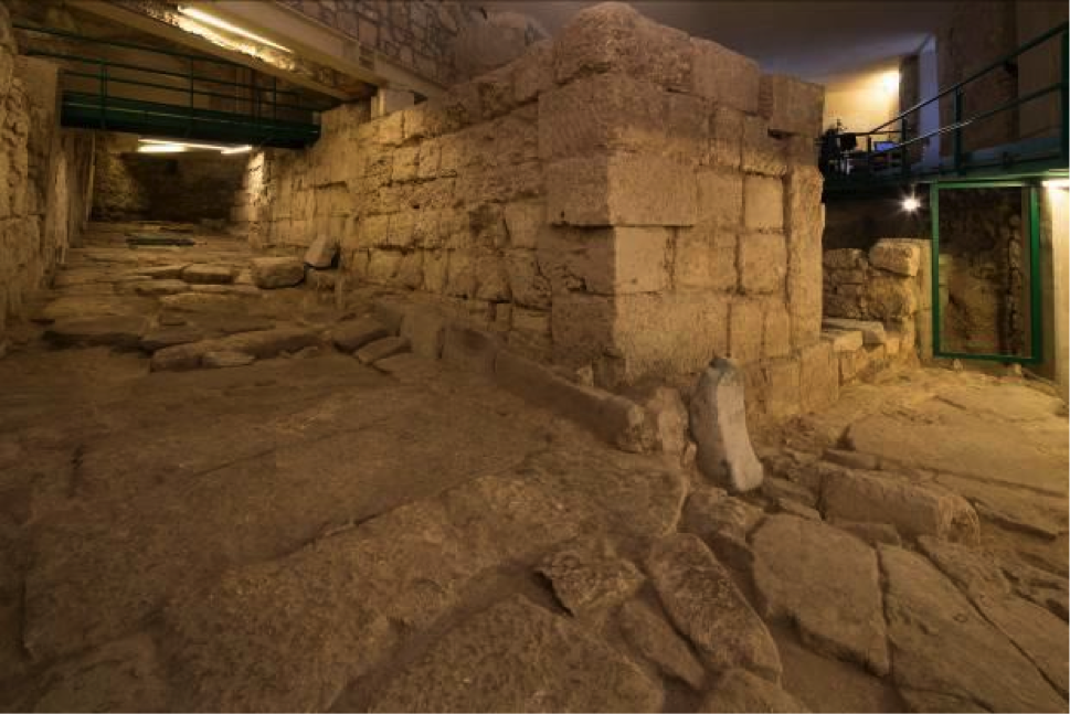


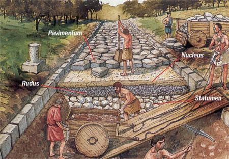
Its width is perfectly aligned with Roman building techniques for urban roads, foreseeing a roadway of between 4 and 5 metres. At a time just after it had been built and as a result of the construction of a portico to the West, some changes were made to the road, narrowing it to 3 metres, while it heads in a different direction to the original one, bending to the East. The stones on those roads were also called basoli paving stones (figs 4-5).
Paved roads were the emblem of town status, so were used in clear urban connotation areas, both when intra moenia, and when they were outside the walls so the habitat could be subsequently expanded; but were still considered a part of the town.

Bibliografia
- P.J. ADAM, L’arte di costruire presso i romani. Materiali e tecniche, Milano 1989.
- C. AGOSTINI, F. SANTI, La strada Bologna-Fiesole del II secolo a.C. (Flaminia Militare). Storia e testimonianze archeologiche di una ricerca sull’Appennino Tosco-emiliano, Bologna 2000, pp. 115, 216.
- M. MARTORELLI, D. MUREDDU, F. PINNA, A.L. SANNA, Nuovi dati sulla topografia di Cagliari in epoca tardoantica e medievale dagli scavi nelle chiese di S. Eulalia e del Santo Sepolcro: Notiziario, in RAC, 79, 2003, pp. 365-408.
- M. MATTEAZZI, Costruire strade in epoca romana: tecniche e morfologie. Il caso dell’Italia settentrionale, in Exedra, 1, 2009, pp. 17-38.
- D. MUREDDU, 23 Secoli in 7 metri. L’area archeologica di S. Eulalia nella storia del quartiere, in MARTORELLI, MUREDDU 2002a, pp. 55-60.
- D. MUREDDU, Le indagini sotto la chiesa di S. Eulalia, in R. MARTORELLI, D. MUREDDU, Scavi sotto la chiesa di S. Eulalia a Cagliari. Notizie preliminari, in AM, 29, 2002, pp. 283-286.
- D. MUREDDU, Evoluzione storico-topografica del quartiere e della città, in Martorelli et al. 2003, Nuovi dati sulla topografia di Cagliari in epoca tardoantica e medievale dagli scavi nelle chiese di S. Eulalia e del Santo Sepolcro: Notiziario, in Rivista di Archeologia Cristiana, 79, 2003, pp. 389-392.
- J. ORTALLI, Strade di Bologna romana. Tipologia e topografia, in Strenna storica bolognese, 34, pp. 283-305.
- F. PINNA, Frammenti di storia sotto S. Eulalia. I risultati delle campagne di scavo 1990-1992, in MARTORELLI, MUREDDU 2002a, pp. 33-54.
- F. PINNA, Le indagini archeologiche. La chiesa, in MARTORELLI et al. 2003, pp. 372-381.
 VR
VR