Ancient roads
Two main roads ensured internal connections between the island’s major ports during the Roman Era: Karales (Cagliari), Turris Libisonis (Porto Torres) and Olbia.
The first guaranteed connections with Karales and Turris Libisonis, known by the milestones with three definitions: a Turre, a Turre Karalis and a Karalibus Turrem.
From this, a second road branched off to Olbia, passing by the mansiones of Hafa (Mores) and Luguidonis castra (Nostra Signora di Castro - Oschiri).
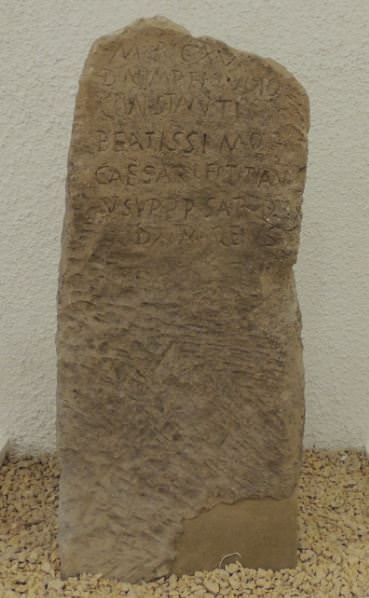
Thanks to the directions in the Itinerarium Antonini and the finding of several milestones, experts have been able to hypothesise that the point from which the road that allowed you to reach Olbia, a Karalibus Olbiam from Cagliari branched off was close to the northern limit of the town of Bonorva. It was already built in the Republican era, but only gained economic importance during the Imperial era, especially starting with the Severan Era (end of 2nd to beginning of 3rd century A.D.), as shown by the large number of milestones found, that show the continuous renovation work carried out still at the end of the 4th century A.D. (figs. 1-2).

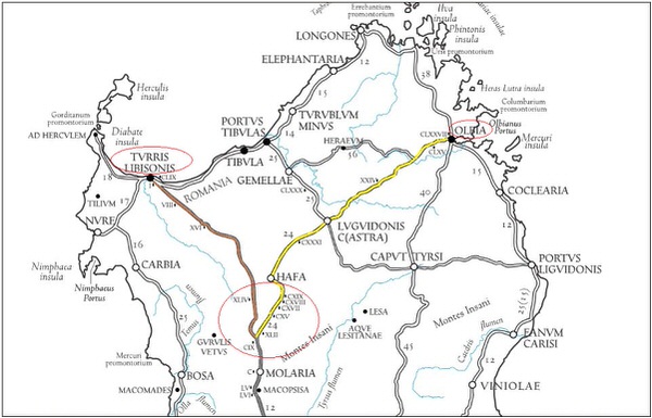
In spite of the difficulties due to the loss of most of the milestones and the disappearance of the roads, it is still possible to identify the itinerary, that wound for 65 miles, i.e. 96 km according to calculations (fig. 3).
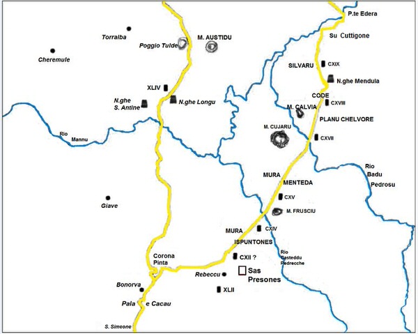
Once past Bonorva, the road for Olbia went eastwards following a track that crossed the modern road for Rebeccu near to the church of San Lorenzo. It continued in a northeast direction, leaving Monte Frusciu on the right, to reach Mura Menteda; it then went east of Monte Cujaru, over the Rio Badu Pedrosu, between Monte Calvia and Planu Chelvore, downhill towards Code and Silvaru on a route almost straight north, and after a diversion towards Cuttigone, it went over the Riu Mannu, and towards Hafa (Mores). The road route for Turris Libisonis divided from the Cagliari-Olbia road north of Bonorva and continued on towards the Santu Antine nuraghe, then towards Poggio Tulde and alongside Monte Arana, before heading for Turris (fig. 4).
Bibliografia
- BELLI E., La viabilità romana nel Logudoro-Meilogu, in Il nuraghe S. Antine nel Logudoro-Meilogu (a cura di A. MORAVETTI), Sassari 1988, pp. 330- 395.
- CAPRARA R., La necropoli di S. Andrea Priu. Sardegna Archeologica. Guide e Itinerari, 3, Sassari 1986.
- MASTINO A., Storia della Sardegna antica, Nuoro 2005.
- SECHI M., Viabilità e dinamiche insediative in età romana nel territorio di Bonorva, in Studi sul paesaggio della Sardegna romana (a cura di G. PIANU, N. CANU), Mores 2011, pp. 83-103.
- SECHI M., La viabilità nella Sardegna romana tra le stationes di Hafa e Molaria, in Alta Formazione e Ricerca in Sardegna. Atti del Convegno di Studi Giovani Ricercatori (Sassari 16 dicembre 2011), a cura di E. CICU, A. GAVINI, M. SECHI, Raleigh 2014, pp. 18-36.
- TARAMELLI A., Fortezze, recinti, fonti sacre e necropoli preromane nell'agro di Bonorva (Prov. di Sassari), in Monumenti Antichi pubblicati a cura dell’Accademia dei Lincei, XXV, 1919, coll. 765-904.
 VR
VR