Castle of Balaiana
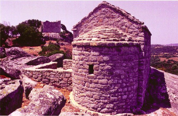
Three kilometres as the crow flies from the palace of Baldu, there is the castle of Balaiana which is still linked by a footpath to the church of San Leonardo, originally the castle’s chapel (fig. 1).
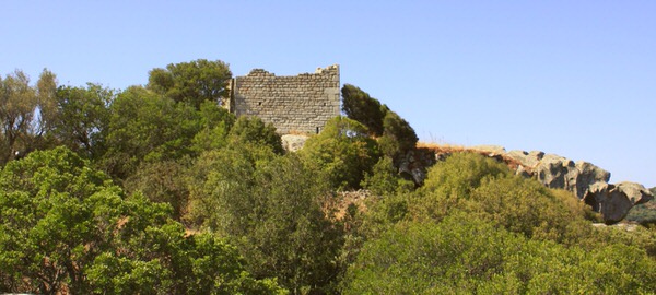
The structure is located on Mount San Leonardo at 299 metres above sea level, from which it dominates a large portion of territory and the roads which joined it to the most important ports and cities of the Giudicato. This is why awarding it a defensive function of the internal borders and the surrounding areas has been suggested.
The fortress was probably built by Giudice Constantine I during the eleventh century with the work of craftsmen from Pisa. This hypothesis appears to be supported by some specific building details, in fact the castle was made entirely of square granite blocks, whose interlocking system did not need any mortar. The castle is characterised by a trapezoidal tower divided into two rooms, with access from the eastern side (figs. 2-3).


The existence of stone alignments in the surrounding plateau has led to the hypothesis that there were curtain walls placed there to prevent access from all directions.
The castle of Balaiana is mentioned in the Condaghe Bonarcado (first decades of the XII and mid-XIII centuries), which reports the dispute which began between the Giudice of Gallura Constantine III and the sons of his predecessor Comita Spanu, who had occupied the fortress. The latter was donated by Barisone of Arborea to the monastery of Santa Maria of Bonarcado in 1146; its destruction can be traced back in general to the Catalan-Aragonese people.
The conditions of severe neglect of the castle imposed major restoration interventions at the turn of the last century (fig. 4).
Bibliografia
- R. CAPRARA, A. LUCIANO, G. MACIOCCO (a cura di), Archeologia del territorio. Territorio dell’archeologia. Un sistema informativo territoriale orientato sull’archeologia della regione ambientale Gallura, Sassari 1996, p. 285.
- Sardegna Cultura s.v. Luogosanto, Castello di Balaiana, in http://www.sardegnacultura.it/j/v/253?s=17934&v=2&c=2488&c1=2173&t=1.
- F. C. CASULA, Tavola 40, in R. PRACCHI, A. TERROSU ASOLE (a cura di), Atlante della Sardegna, Fascicolo II, Roma 1980, pp. 109-114.
- R. CAPRARA, La Gallura tra tarda antichità e medioevo. Appunti da una ricerca, in R. CAPRARA, A. LUCIANO, G. MACIOCCO (a cura di), Archeologia del territorio. Territorio dell’archeologia. Un sistema informativo territoriale orientato sull’archeologia della regione ambientale Gallura, Sassari 1996, pp. 146-147.
- G. FLORIS, Signoria, incastellamento e riorganizzazione di un territorio nel tardo Medioevo: il caso della Gallura, tesi di dottorato, Universitat de Barcelona, a.a. 2012-2013, pp. 17-18.
- F. FOIS, Castelli della Sardegna medioevale, Cinisello Balsamo 1992, p. 188.
- D. PANEDDA, Il giudicato di Gallura. Curatorie e centri abitati, Sassari 1978.
- F. PINNA, Castello di Balaiana e chiesa di San Leonardo, in L’Alta Gallura, territorio, cultura e tradizioni, pp. 15-18.
- F. PINNA, Archeologia del territorio in Sardegna. La Gallura tra tarda antichità e medioevo, Cagliari 2008, pp. 100-102.
- M. VIRDIS (a cura di), Il condaghe di Santa Maria di Bonarcado, Nuoro 2003, pp. 9-10; 192-193.
 VR
VR