Archeological area of Sant'Eulalia
- Late Ancient and Early Medieval Age, IV cent. A.D. - VIII cent. A.D.
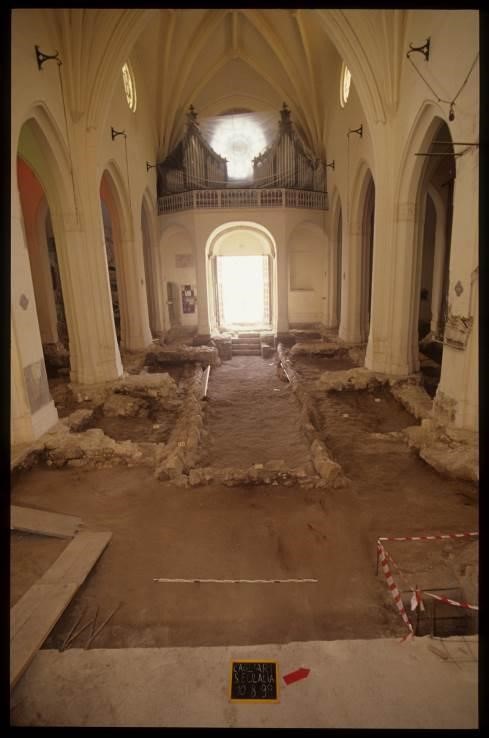
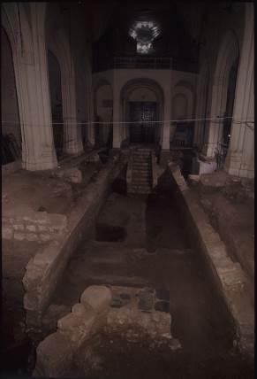
The archaeological area of Sant’Eulalia extends over 900 m2 under the church of the same name with sediment and structures telling a 23 century-long story: from the IV B.C. to the start of the VIII century A.D. with no interruptions; then again from the XIV century until now.
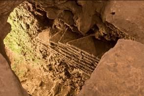
The site's oldest certification dates to the late-Punic period with reference to an openair quarry created in the limestone bedrock, used until III A.D. to extract blocks to be used for building purposes. Traces of that activity can be found in the orthogonal grooves still visible; filled with limestone powder when no longer used to obtain a single level. The blocks were then used to build a terrace, of which we still have three rows in an opus isodommum on surfacing rock, identified as the site's oldest Stratigrahic Wall Unit. That base was for a sanctuary, then outside town, to make a border area sacred, of which there are still some vague traces. Inside, they would have worshipped a Semite divinity. This concerned the thesaurus - only remaining evidence - provided with a podium and a deep well, found full of earth mixed with ashes, ceramic fragments and various metal finds, including 307 bronze coins datable between III A.D. and the Imperial Roman period. The thesaurus (fig. 1) was then disused and knocked down; what remained of its structures was obliterated by layers of earth, ashes and crumbled limestone.

Fragments of African terracotta sigillata D come from this fill-up, datable between the starts of the IV and V centuries A.D., which have formed the terminus post quem of that abandon. This stage can be attributed to an urban area reorganisation project referred to a paved road (fig. 2) separating the two large building complexes still visible; while construction of a large portico (fig. 7) is related to a second intervention, slightly later.
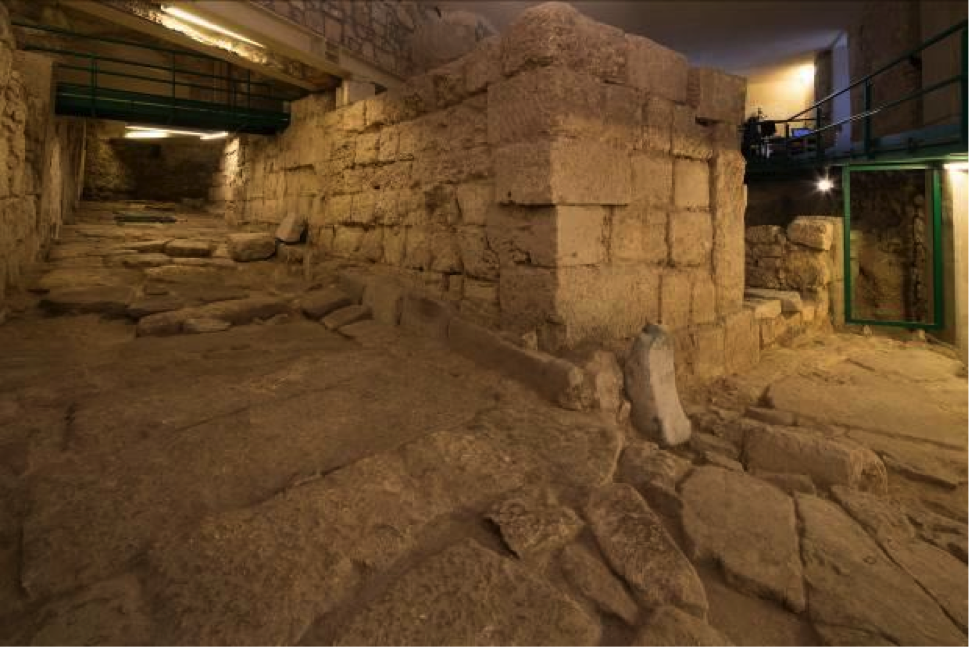
The road built with large flagstones was originally 4.20 metres wide, going North-East/South-West and sloping towards the sea; in ancient times this would not have been as steep as it is now. This imposing public works highlights the importance of the area or of the road itself. The short stretch remaining to the North-East of the site is all that remains of its width. It was probably narrowed to create more space for private use towards the end of the VI century. There are three pits on the surface of this road. They were probably needed to maintain the sewers running beneath it. The latter are quadrangular in shape with a vaulted cover, but were made using two different techniques: in one case the lower stretch was dug in the rock while the upper one was made with large limestone slabs; the second shows walls covered with bricks and, on the bottom, a layer of brick fragments to level it (fig. 3).
Coeval to the road, the remaining environment of a private home with stone threshold still showing the holes for hinges. The fact that a part was obliterated shows changes occurring between the V and VI century when the road was narrowed. The wall structure raised to delimit the road was built using the frame technique: a series of straight stone elements fixed at regular distances, to hold the rows laid out in the middle spaces. On the opposite side of the road, there is a second block built slightly later than the first, split into several areas including a courtyard with well and latrine, two ramps to reach the landing and at least one upper floor. Behind it rooms well served by a cistern; others in the south-east sector were added in the VI century. These new spaces had their floor raised, with stone troughs arranged on them functional for a new use, which seemed to be rural so revealing the socio-economic change to the area (fig. 4).

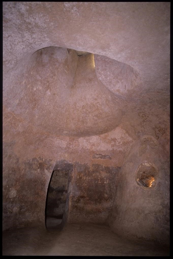
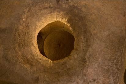
A specific element of the district at a time later than the IV century must have been the porticus. On the west side, this shows a row of columns covered with stucco on marble bases, while on the opposite one it was closed by a double wall. The portico must have represented a monumental public works, majestic in size and decoration: 8 metres wide with a known length of 24 metres. Its real extension is difficult to calculate because of the houses overlooking the archaeological remains after the church perimeter; the inner wall was coated in coloured plaster. The structure was surmounted by a sloping, tiled roof and decorated by fictile ante-fixes representing gorgons and acanthus bushes, all works of Roman Figlinae active during the first imperial age. The interior was paved with small, irregular limestone and marble slabs on a lime base; here you have the opening of a bottle-shaped cistern (fig. 6). It provided water to those frequenting the zone: proven by amphora fragments found on the bottom. When it was found, the mouth of the cistern (fig. 6) seemed to be closed by a stone stopper, specifically arranged to preserve the coin treasures hidden inside at a time of danger, when the area was slowly losing its function. Behind the portico's outer wall they found a drainage canal; however, was part of an ampler hydraulic engineering project: a series of tegulae mammatae were fixed to the wall structure thus creating an air chamber to insulate the wall coatings against humidity. In front, a number of small canals and a lowered floor led to imagine the presence of areas used for ornamental plants to frame the colonnade and certainly a small canal conveying waters going towards the water reserves.
The V century A.D. was characterised by events that changed the political structure of Sardinia and, consequently, the urban one of its centres. At the end of the previous century, in 395, the emperor Theodosius split the Empire between his two sons, Honorius and Arcadius, They obtained, respectively, the western and eastern parts of the Empire. Between 455 and 467 the island came under vandal dominion, despite the fact that the Byzantine emperors from Valentinian III (425-455) to Leone I (457-474) tried several times to re-establish imperial authority over the territory. The western part of the Empire with its offshoots became weaker and weaker and was badly defended. People pressing at the borders, like the Vandals, and internal chaos slowly undermined its stability causing it to collapse in 476 A.D. Those events reverberated on distribution of urban spaces: between the IV and V century you can note a rethinking of previous structures, on which others were built ex novo, with different uses; at times modifying them adding dividing walls.
In the light of those historical occurrences, the porticus (fig. 7) was transformed considerably to meet the town's different needs: after the mid V century A.D. limestone blocks were inserted between the column drums to create a continuous wall for almost all the northern half of its length. This stratagem created a closed space joined to a part of the airy portico and some of its elements were re-used in other structures. In the VI century, they probably created an internal division: an orthogonal structure against the wall included a column drum in the material it was made of. It is probable that some blocks forming the seven rows laid out regularly alongside the southern part of the portico came from this structure; almost indicating a stock ready to be loaded or simply reused. The portico, in its descent towards the sea, would have crossed the paved road if its route had not already been modified with a slight deviation towards the south. That change could be referable to the changes affecting that same road, when its importance was damaged by the creation of the neighbouring portico. From that moment its majesty was sized down in both width and route.

During the mid VI century, Sardinia became a Byzantine province, when the vandals were defeated in 534 by Narses, a general of the emperor Justinian (527-565). The difficult cohabitation between the oriental element and populations living in the Sardinian interior gave the Ostrogoths of Totila the chance to reach the island and occupy some centres, including Cagliari, between 551 and 552.
Towards the end of the VI century and the start of the VII, the changed political situations caused a time of instability, This was to continue for quite some time and the town responded with disintegration on one side and reconstructions on the other. The centre continued its life continuously on the previous one with no interruptions. With those changes, structures were stripped to recover building material, as happened to the rear part of the portico and to the transversal wall, which seem to have collapsed. In the area previously occupied by the colonnade's end wall, now obliterated by a landfill, a large environment was created in the VII century. One of its shorter sides, the southern one, became a continuation of the section, which narrowed and marked the paved road on the western side; while the long upper side followed the perimeter of the thesaurus.
The fall of the Prefecture of Africa and resulting administrative vacuum moment is dated to the VIII century; this had a new effect on the demic nuclei. The centre of Carales became "spotted”, with residential areas alternated with others ruralized by progressive landfills; from this its peripheral districts were slowly abandoned, through a deconstruction process ending between the IX and XI century, also found in other peninsular towns The oriental districts of the Byzantine Carales, including S. Eulalia, suffered that end, with a progressive centring of town life far from the sea.
Materials found in the archaeological area do not as yet seem to be datable past the start of the VIII century. This ascertains that the site was not used for residential purposes in a later period. Later on, the district was used as a dump or waste shaft. This meant not just losing the structures visibly, but also any memory of them. They were filled and obliterated by layers of dust, earth and waste creating metres-high layers.
After about seven centuries, this site was once again chosen for the construction of a place of worship, wanted by the Catalan-Aragonese, restoring the area's original vocation. It being named after the Spanish Saint was mentioned by sources as agio-toponym in 1332, while the religious building has been known of since 1365. This first had a single-nave plant, probably responding to the central nave of the church above. There are very few elements of the ancient structure remaining: an oblique wall, visible in the left corner of the current front, a kind of buttress that seems to support the front itself, to then continue under the church at foundation level; perhaps built against earth and lowered into a ditch. That wall sustained a horseshoe structure at the same height. It could be what is left of the original single-nave church. That same church building is thought to have been redone in the XVI century. It was expanded by adopting a three-nave plant with entrance to the west; while the space below was used as a funerary crypt (figs. 8-10).

Bibliografia
- Archivio Centrale dello Stato di Roma.
- Archivio Fotografico della Soprintendenza per i Beni Archeologici per le province di Cagliari e Oristano.
- P. J. ADAM, L’arte di costruire presso i romani. Materiali e tecniche, Milano 1989.
- S. CARA, S. SANGIORGI, La ceramica da fuoco proveniente da Sant’Eulalia a Cagliari. Quaderni. Ministero per i beni culturali e ambientali. Soprintendenza archeologica per le province di Cagliari e Oristano 22 (2), pp. 19-45.
- S. CISCI, M. TATTI, Cagliari, S. Eulalia, 2007-2008. Archeologia Postmedievale: società, ambiente e produzione 11, 2007, pp. 357-358.
- A.M. COLAVITTI, C. TRONCHETTI, Guida archeologica di Cagliari. Sardegna archeologica. Guide e itinerari, Sassari 2003.
- M. CUGUSI, Non solo incoraggiamenti. Dopo 10 anni è il momento di nuove risorse, in R. MARTORELLI, D. MUREDDU 2002a, pp. 15-18.
- S. LUSUARDI SIENA, Fonti archeologiche e iconografiche per la storia e la cultura degli insediamenti nell’altomedioevo. Atti delle giornate di studio (Milano-Vercelli, 21-22 marzo 2002) = Contributi di Archeologia, 3, Milano 2003.
- M. FREDDI, La chiesa di S. Eulalia a Cagliari, in Atti del XIII Congresso di storia dell’architettura (Sardegna), (Cagliari, 6-12 aprile 1963), Roma 1966, pp. 245-251.
- S. GELICHI, Introduzione all’archeologia medievale. Storia e ricerche in Italia, Roma 1997.
- J. M. GURT I ESPARRAGUERA, J.BUXEDA I GARROZ, M.A. CAU ONTIVEROS (a cura di), LRCW I. Late Roman Coarse Wares, Cooking Wares and Amphorae in the Mediterranean. Archaeology and Archaeometry. BAR International Series, 1340, Oxford 2005.
- G. LULLIRI, M.B. URBAN, Le monete della Sardegna vandalica. Storia e numismatica, Sassari 1996.
- R. MARTORELLI, D. MUREDDU, F. PINNA, A.L. SANNA, Nuovi dati sulla topografia di Cagliari in epoca tardoantica e medievale dagli scavi nelle chiese di S. Eulalia e del Santo Sepolcro: Notiziario. Rivista di Archeologia Cristiana 79, pp. 365-408.
- R. MARTORELLI, Archeologia urbana a Cagliari. Un bilancio di trent’anni di ricerche sull’età tardoantica e altomedievale. Studi Sardi 29, pp. 213-238.
- R. MARTORELLI, Un decennio di ricerche archeologiche nella Cagliari catalano-aragonese, in A. CIOPPI (a cura di), Sardegna e Catalogna officinae di identità, riflessioni storiografiche e prospettive di ricerca. Studi in memoria di Roberto Coroneo. Atti del Seminario di studi (Cagliari 15 aprile 2011), Cagliari 2013, pp. 243-268.
- R. MARTORELLI, D. MUREDDU (a cura di), Cagliari, le radici di Marina: dallo scavo archeologico di S. Eulalia un progetto di ricerca formazione e valorizzazione, Cagliari 2002.
- R. MARTORELLI, D. MUREDDU, Scavi sotto la chiesa di S. Eulalia a Cagliari. Notizie preliminari. Archeologia Medievale 29, 2002, pp. 283-340.
- R. MARTORELLI, D. MUREDDU, Cagliari, scavi archeologici nelle chiese di Sant’Eulalia e Santo Sepolcro. Aristeo. Quaderno del Dipartimento di Scienze Archeologiche e Storico-artistiche 1, 2004, pp. 317-318.
- R. MARTORELLI, D. MUREDDU, Cagliari: persistenze e spostamenti del centro urbano fra VIII e XI secolo, in R. MARTORELLI (a cura di), con la collaborazione di S. MARINI, Settecento-Millecento d.C.: storia, archeologia e arte nei ‘secoli bui’ del Mediterraneo. Dalle fonti scritte, archeologiche ed artistiche alla ricostruzione della vicenda storica: la Sardegna laboratorio di esperienze culturali. Atti del Convegno di Studi (Cagliari, Dipartimento di storia, Beni Culturali e Territorio, Cittadella dei Musei – Aula Roberto Coroneo, 17-19 ottobre 2012), Cagliari 2013.
- A. MASTINO (a cura di), Storia della Sardegna antica. La Sardegna e la sua storia, 2, Nuoro 2005.
- L. MURA, Un’iscrizione dipinta dall’area archeologica di Sant’Eulalia, in F. CENERINI, P. RUGGERI (a cura di), Epigrafia romana in Sardegna. Atti del I Convegno di Studio (Sant'Antioco, 14-15 luglio 2007), Roma 2008, pp. 279-283.
- D. MUREDDU, 23 Secoli in 7 metri. L’area archeologica di S. Eulalia nella storia del quartiere, in R. MARTORELLI, D. MUREDDU 2002a, pp. 55-60.
- D. MUREDDU, Le indagini sotto la chiesa di S. Eulalia, in R. MARTORELLI, D. MUREDDU, Scavi sotto la chiesa di S. Eulalia a Cagliari. Notizie preliminari. Archeologia Medievale 29, 2002b, pp. 283-286.
- L. PANI ERMINI, Città fortificate e fortificazione delle città italiane tra V e VI secolo, in A.M. GIUNTELLA, M. SALVATORE (a cura di), ‘Forma’ e cultura della città altomedievale. Scritti scelti, Spoleto 2001.
- F. PINNA, Frammenti di storia sotto S. Eulalia. I risultati delle campagne di scavo 1990-1992, in R. MARTORELLI, D. MUREDDU 2002a, pp. 33-54.
- F. PINNA, Le indagini archeologiche. La chiesa, in MARTORELLI, et al. 2003, pp. 372-381.
- F. PINNA, Il corredo funerario nella Sardegna post-medievale: la cripta della chiesa di S. Eulalia a Cagliari, in Fonti archeologiche 2003, pp. 323-335.
- F. PINNA, Una produzione di ceramica comune nei siti tardo-antichi e altomedievali della Sardegna: note sui manufatti decorati a linee polite dallo scavo di S. Eulalia a Cagliari, in LRCW1, pp. 267-284.
- S. SANGIORGI, Le ceramiche da fuoco in Sardegna: osservazioni preliminari a partire dai materiali rinvenuti nello scavo di S. Eulalia a Cagliari, in LRCW1, pp. 255-266.
- S. SANGIORGI, Raffigurazioni inconsuete su lucerne africane in Sardegna. Le attestazioni dalla chiesa di S. Eulalia a Cagliari, in R.M. BONACASA CARRA, E. VITALE (a cura di), La cristianizzazione in Italia tra tardoantico e altomedioevo. Atti del IX Congresso Nazionale di Archeologia Cristiana (Agrigento, 20-25 novembre 2004), II, Palermo 2007, pp. 1369-1386.
- S. SANGIORGI, S. CISCI, Scavi archeologici nella chiesa di S. Eulalia a Cagliari. I Beni Culturali: tutela e valorizzazione 11 (2), 2003, pp. 7-11.
- A.L. SANNA, Le indagini archeologiche. La chiesa, in R. MARTORELLI et al. 2003, pp. 381-384.
- F. SEGNI PULVIRENTI, A. SARI, Architettura tardogotica e d’influsso rinascimentale. Storia dell’arte in Sardegna, Nuoro 1994, Scheda 7 “S.Eulalia” (ante 1371-XV sec.).
- M. TACI SCORDO, Cagliari quartiere della Marina: chiesa di Sant'Eulalia: defunti inumati in essa dal 1816 al 1579.
- W. TREADGOLD, Storia di Bisanzio, Bologna 2009.
- M.B. URBAN, Da Bonaria a Castel di Cagliari: programma politico e scelte urbanistiche nel primo periodo del Regno di Sardegna catalano-aragonese. Medioevo. Saggi e Rassegne 22, 1997, pp. 94-148.
- M.B. URBAN, Cagliari tra Tre e Quattrocento, Cagliari 2000.
 VR
VR