The Castle della Fava
- Middle Ages, XIII-XV century A.D.
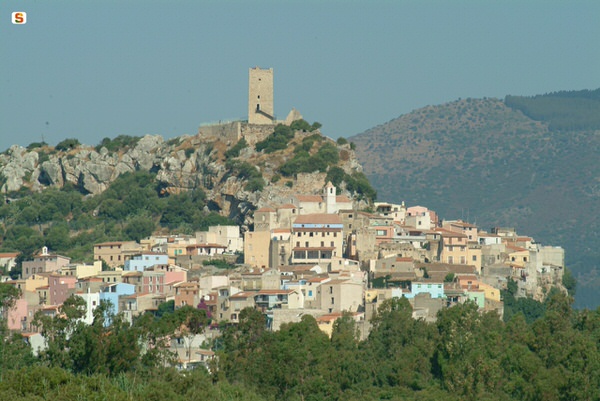
The Castello della Fava (fig. 1) is located on top of a high limestone hill from which it overlooks the town of Posada, in the province of Nuoro (North-Eastern Sardinia). Thanks to its elevated position, it could easily control not only the surrounding plain, but also the mouth of the River Posada and a large portion of the east coast of Sardinia. It therefore had a strategic role in the defence of the territory precisely because of the possibility of spotting the arrival of enemies both from inland and from the sea. It was also close to the road a Portu Tibulas-Carales, built in Roman times in order to connect Cagliari with the area of Santa Teresa di Gallura, along the east coast.
We do not know the exact date of its construction, but it already existed in the second half of the thirteenth century, since it is mentioned in the documents of that time. It was built on the initiative of the Visconti family of Pisa, for whom the fortress was the residence, right on the border between the Giudicato of Gallura, to which it belonged, and that of Arborea. The fortress, which had a leading role in many complex historical events, was controlled alternately either by the rulers of Gallura or by those of Arborea. In 1324, it passed under Catalan-Aragonese dominion and, after a few intervals during which it returned among the possessions of Arborea, the castle and the village of Posada returned permanently under Iberian rule in 1409, and were then granted in fief to the Carroz family in 1431 and elevated to the rank of Barony.
The fortress “della Fava" also included, in addition to the castle itself, the fortified village. It is probable that originally the village of Posada stood further west than the fortress, in the area where the current district of Santa Caterina is located. Subsequently, between the second half of the fifteenth and the early sixteenth century, because of the war between Arborea and Aragon and later because of the Saracen invasions, the inhabitants must have moved to the hill, in order to enjoy the protection of the stronghold. From that moment on, the fortress della Fava became an integral part of the new village of Posada.
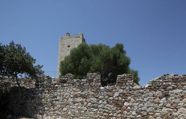
The castle was surrounded by multiple protective walls built directly on the rock and provided with walkways protected by battlements, where the soldiers could guard the surrounding territory and defend the fortress in case of enemy attack. The outer perimeter, of which only a few remains are left, enclosed a large area and had some openings facing the sea, useful for spotting the arrival of enemy ships (fig. 2). A gate allowed crossing this first barrier and entering the space delimited by the second circuit wall, which led to the inner walls of the castle. This is the so-called "outer wall", which protected the fortress from the assault of war machines such as rams and trebuchets. A passage allowed going beyond these walls and to continue towards the castle along a path which suddenly turned right, sandwiched between the outer wall and the inner walls. Once beyond the path, you were faced with a final set of walls, the inner one, built on top of the hill (fig. 2). A portal, preceded by a series of steps carved into the rock, allowed access to the parade ground, a large open space at the centre of which the high square tower is still visible (fig. 3).
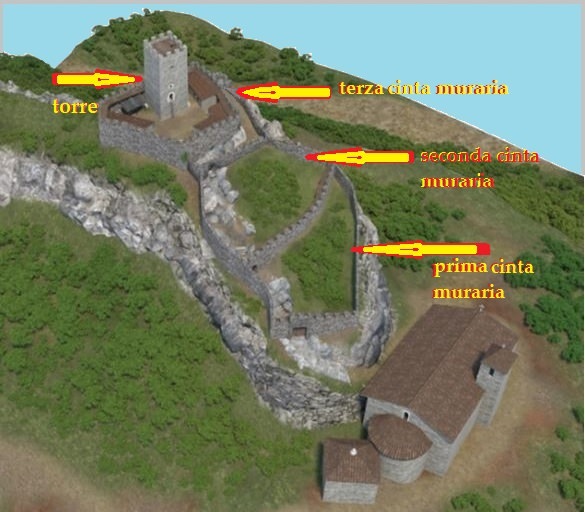
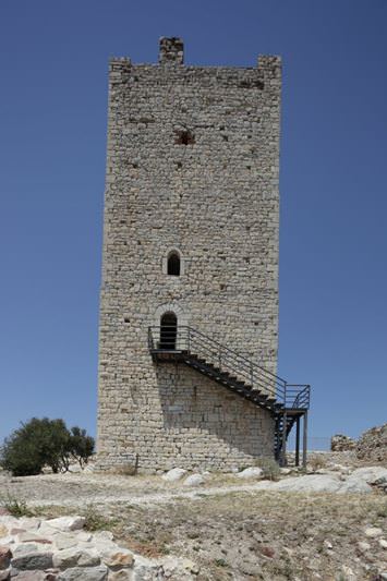
The tower is about 20 metres high and is characterised by having the entrance placed at a level higher than the parade ground. Access to the tower (now possible thanks to an iron staircase) was carried out by means of a wooden or rope ladder, which could be pulled back quickly in order to prevent the entry to any enemies who might have overcome the walled perimeters (fig. 4). The top of the tower was crowned with battlements, while the interior space was divided into three floors, connected by steep wooden stairs. Some small openings, allowing light into the rooms, were made in the walls and these enabled controlling the surrounding territory. Military exercises and the gathering of troops and weapons took place in the parade ground, i.e. the large open space surrounded by the walls and overlooked by the tower. Here, there were three large underground cisterns which collected rainwater and guaranteed the water supply in the event of a prolonged siege. Against the walls of the courtyard there were also several structures, probably warehouses or stables, of which only a few traces remain (fig. 5).

Bibliografia
- A. CASTELLACCIO, Note sul Castello della Fava, in Medioevo. Saggi e Rassegne, XV, 1983, pp. 55-83.
- R. CORONEO, Architettura romanica dalla metà del Mille al primo ‘300, Nuoro 1993.
- FG. FLORIS, Il castello medioevale della Fava (Posada). Acta historica et archaeologica mediaevalia 29, pp. 257-297.
- F. FOIS, Castelli della Sardegna medioevale (a cura di B. FOIS), Cagliari 2012.
- L. PILONI, Carte geografiche della Sardegna, Cagliari 1997.
- A. SANCIU, Fenici lungo la costa orientale sarda. Nuove acquisizioni. Fasti On Line Documents & Research 174.
- G. ZIROTTU, Posada. Un borgo sardo e il suo castello, Nuoro 1999.
 VR
VR