The village of Tiscali: an important archaeological and natural context
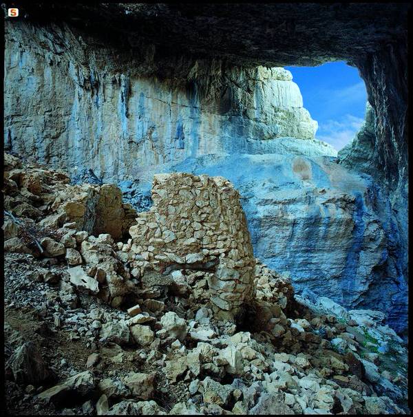
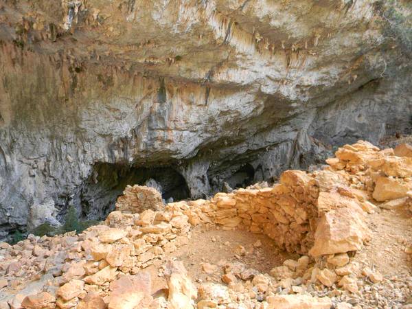
The settlement of Tiscali (figs. 1, 2, 3) was built inside a karstic truncated-cone shaped sinkhole which originated, in very ancient times, following the collapse of the ceiling of the large hall of a cave. It was located on the summit of Mount Tiscali (about 500 m a.s.l) which rises to the right of Rio Sa Oche in the Valley of Lanaittu, in a privileged controlling position, at the border between the Supramonte of Dorgali and the Supramonte of Oliena.
The village was built entirely along the walls of the sinkhole and is not visible until the interior of the cavity is reached through the large opening in the rock wall. Known and visited by shepherds from Dorgali and Oliena, visited in 1910 by Ettore Pais, when it was still excellently preserved, and in 1927 by Antonio Taramelli, it was interpreted by the two scholars as a refuge for the Sardinian people during the Roman conquest of Sardinia. Since then, decades of neglect and looting have significantly damaged the site which, nevertheless, remains a very suggestive place. The huts, which are now largely collapsed, are very small, with a circular and elongated oval plan. The walls, preserved up to a reasonable height, were built using rough-hewn local limestone rubble. One of the huts has projecting walls with a modest thickness which originally must have supported a conical roof of branches; a small niche and some cabinets are still visible inside, while the entrance still has a wooden architrave in place (fig. 4).
Investigations by the Archaeological Heritage Department (1999 and 2003 excavations) and surface collections have allowed recovering materials from the Nuraghic Middle Bronze Age (XVI-XIV cent. B.C.), Iron Age (IX-VI centuries B.C.), and Roman Age (II-I centuries B.C.).
In general, the archaeological evidence allows us to interpret it as a civil settlement, consisting of housing facilities, warehouses, fencing for animals, etc., related to the exploitation of the agricultural-pastoral area (Lanaittu Valley, the plateaus and neighbouring clearings) built in a location which was naturally sheltered and protected both from bad weather and summer heat (fig. 5).


Bibliografia
- ANGIUS V. (a cura di CARTA L.), Città e villaggi della Sardegna dell'Ottocento, Nuoro 2006, p. 992.
- DELUSSU F., L'incontro tra Sardi e Romani in Barbagia: l'evidenza del sito di Tiscali, in Sardegna Mediterranea, 25, 2009, pp. 69-72.
- LO SCHIAVO F., La voragine di Tiscali-Oliena, in Sardegna centro-orientale dal neolitico alla fine del mondo antico, Sassari, 1978, pp. 95-96.
- MORAVETTI A., Serra Orrios e i monumenti archeologici di Dorgali, Sardegna Archeologica. Guide e itinerari, 26, Sassari 1998, pp. 97-105.
- MORAVETTI A. (a cura di), Carbonia-Fonni, in La Sardegna. I Tesori dell’Archeologia, La Biblioteca della Nuova Sardegna, vol. 3, Sassari 2011, pp. 98-103.
- PAIS E., Tiscali nel Nuorese, in Rivista d'Italia, febbraio 1911, pp. 250-263.
- TARAMELLI A., Edizione archeologica della Carta d’Italia, Foglio 208 (Dorgali), Firenze 1929, pp. 31-32, n. 1.
- TARAMELLI A., Dorgali (Nuoro) Esplorazioni archeologiche nel territorio del Comune, in Notizie degli Scavi, IX, 1933, pp. 353-357.
 VR
VR