The port of Arbatax
Arbatax has had port structures since ancient times.
Roman Age sources cite a Sulpicius Portus whose position, according to scholars, was most probably along the Tortolì-Arbatax coast, near the area of today's pond.
Due to the poor, difficult communication routes between Ogliastra and the rest of the Island, the port has always been an efficient connection system with the outside, from both a trading and tourism point of view (figs. 1-2).
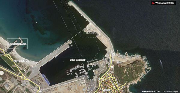
The modern history of the port of Arbatax began in 1861 when they decided to build it on its current site. Works lasted ten years, with difficulties and interruptions forcing the Municipality to declare that the enterprise had failed. After years of questions and protests, works started again in 1882 and ended in 1893. In 1894 it was connected to the railway line to Cagliari (fig. 2).
The port was expanded considerably in the mid XIX century thanks to the actions of fishermen and shipowners from the Pontine islands which, though mainly for the export of charcoal, gave a strong boost to trading in local products
Max Leopold Wagner, who stayed in Tortolì in 1907, told of his visit to Arbatax as follows «… We took a trip to the port village of Arbatax where ferries of the General Italian Navigation land twice a week. The solitary port, surrounded by mountain heights and with a cliff in its midst, is very picturesque. It owes its singular name, Arbatax, to the Saracens. During their frequent raids they called the old massive tower standing at the port entrance “the fourteenth” on the coast (Arabic “arba’tâscer”=fourteen)…».
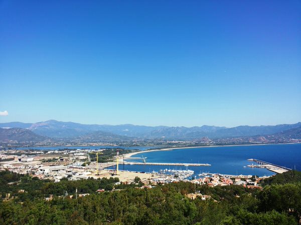
In the Sixties of the XX century, the port grew once more thanks to the expansion of structures linked to the sea transport of materials produced by the Arbatax paper mill, and also for the launch of the Genova-Olbia-Arbatax line and the arrival (1972) of Intermare Sarda (fig. 3).
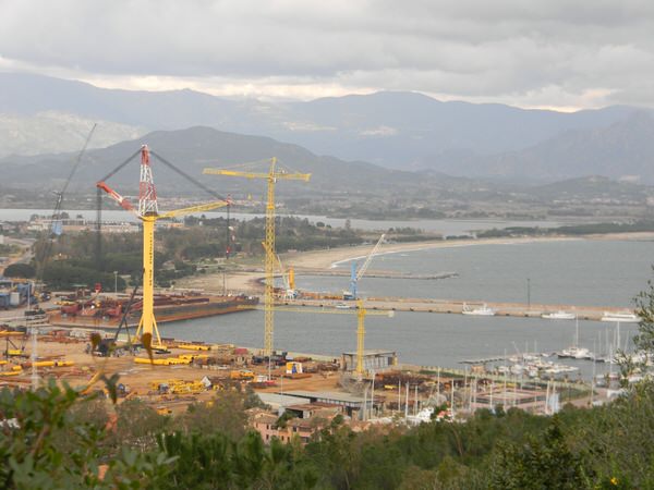
The port now operates as a merchant stopover, well supplied with large docks and goods storage areas. It also has a dock with about 80 berths for boaters and is an attraction for tourists visiting Ogliastra (fig. 4).

Bibliografia
- V. NONNIS, Il porto di Arbatax, in Ogliastra. Antica Cultura, Nuova Provincia. I Paesi, Sestu-Bari Sardo 2005, p. 146.
- N. C. VELLA, La Geografia di Tolomeo e le rotte marittime mediterranee, in L. DE MARIA, R. TURCHETTI (a cura di), Rotte e porti del mediterraneo dopo la caduta dell’impero romano d’Occidente. Continuità e innovazioni tecnologiche e funzionali, Genova 2004, pp. 21-32.
- G. PORCU, Il porto di Arbatax nella seconda metà dell’Ottocento, in Studi ogliastrini. Cultura e società, VII, 2002, pp. 249-291.
- C. ARIMONDI, Porto di Arbatax, in MINISTERO DEI LL. PP., Atti della commis-sione per il piano regolatore dei porti del regno, Porti delle isole di Sicilia e Sardegna, vol. III, Bergamo 1910, pp. 195-198.
- M. L. WAGNER, Reisenbilder aus Sardinien. IV: Sarrabus und Ogliastra, in Globus. Illustrierte Zeitschrift für Länder – und Völkerkunde XCIV (1908), pp. 40-45 (nella riedizione M. L. WAGNER (a cura di G. PAULIS), Immagini di viaggio dalla Sardegna, Nuoro 2001).
 VR
VR